 en
en
 de
de
 ru
ru
 uk
uk
 es
es
Currency selection
The entire agricultural market on one website

The usage of unmanned aerial vehicles (UAV) in agriculture began in Japan. The territory of this country for two decades processes one of the most popular models of Yamaha RMAX. This model sprays pesticides and fertilizers.
Since 1983, the Ministry of Agriculture of Japan has been particularly active in addressing the problem of the aging of the rural population. To solve this problem, it was proposed to modernize agriculture in such a way as to attract young people.
The company "Yamaha" began the developing of an unmanned aerial vehicle to help with solution of field problems, and in the 1990s, the first equipment was implemented. As of today, 40% of Japanese rice fields are processed by drones. The technology is exported to South Korea and more recently to Australia.
One drone can control hundreds of hectares and collect information on the state of crops. The usage of drones in agriculture is one of the most promising directions of application of this technology. The UAVs can be effectively used for planning and controlling the stages of agricultural production, as well as for chemical processing of crops and other plants. In this case, the main criterion for the implementation of UAVs is economic efficiency. The main possibilities of using unmanned aerial vehicles in agriculture are presented in this article.
The drones are only platforms, on which cameras and multispectral sensors are installed, as well as other equipment for data acquisition and for processing crops. The data are obtained by using all these sensors and are stored digitally in the form of tables and maps. This information helps the farmer by the decision-making process.
The UAVs allow creating a cartographic base with the exact coordinates of all objects that can help you to conduct a visual analysis of objects in the future with a resolution of up to several centimeters per pixel. On this basis, it will be possible to apply vector layers: fields, infrastructure, and roads. This basis allows you to calculate the exact areas, distances, resource requirements, etc. It is convenient to determine the objective area of tilled fields, hayfields, pastures, laylands, fallow lands, fall-plowed fields, sowing fields, insufficient sowing fields and additional sowing fields.
The results of aerial photography allow registering areas in the Cadastre. The aerial photography of UAV is more detailed than a space image. The image resolution is possible in centimeters per point, due to flight altitudes from 100 up to 600 meters above the ground. In addition, UAVs allow you to shoot even under the cloudy conditions that is inaccessible to satellites and makes it difficult to use aircraft.
Creating 3D maps
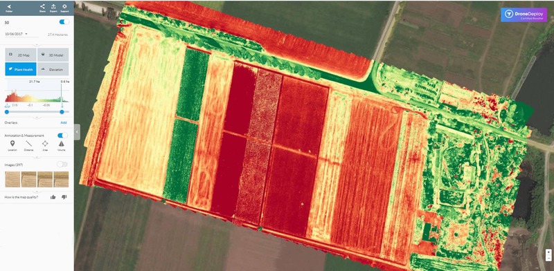
The main task of drones in the agrarian and industrial complex is modeling of three-dimensional terrain maps. Accurate data on the land plot, its condition, relief and boundaries are the basis of a good harvest and, as a result, profit.
Thereafter the drones fly around the area and the experts unload data from these unmanned aerial vehicles. Initially, these are just photos from different angles, which were shooted in sequence. The construction of a 3D map is used in special programs, as a rule, they are provided by creators of UAVs. The most popular programs are DataMapper, Pix4D or DroneDeploy. The web-platforms form relief terrain models that show every meter of the field in detail. On the basis of the obtained data it is possible to form routes of a vehicle and accurately calculate the required amount of seeds, fuel, etc.
Planting seeds
Increasingly, agrarian IT start-ups, which optimize the usage of drones in agriculture, have begun to develop. Specially created systems of planting seeds with the help of UAV allow to reduce the cost of such work by 85%. The seeds or sprouts are loaded into special small containers that are sprayed across the field. It is remarkable that in the tank there are also nutrients that immediately after planting will provide the plant with all necessary matters.
Applying chemical preparations and mineral fertilizers
UAV is used for application of chemicals and mineral fertilizers on seeds. Devices are equipped with special measuring equipment – special ultrasonic sensors that allow adjusting the height depending on the change in geography during flight. Therefore, drones can scan the ground and spray the optimal amount of fluid, modulating the distance from the ground. The spraying is carried out evenly. It's worth to remark that such drones cost more than the usual one, but the result is worth it: spraying is carried out 5 times faster than with the use of the traditional method, while the amount of the applied fertilizers and mineral substances is significantly saved.
For lovers of organic matter, it is worth marking the application of biological defense technologies, such as trichograms, which are insect parasites that feed on eggs of pests. With the help of drones, they can be quickly diffused in several stages, the trichogram lives in the field for no more than a week, and during this time it can destroy a large number of pests. A big plus here – it is possible to minimize the use of pesticides, as well as cut corners on fertilizers.
The crops state control
It is often difficult to keep track of the field state, especially in bad weather, and this is fraught with risks and redundancies in production. It's worth to remark that the drones help to monitor the crops throughout the season, providing operational information that quickly allows making strategic decisions. It is very important to be able to monitor the state of the grains and find out bacterial infections on the plant stocks.
Devices can also track the development of plant diseases in the early stages, which will prevent possible yield losses. To do this, using near-infrared light spectrum, devices can identify the level of reflection, which allows generating multispectral images. These technologies make it possible not only to find the diseases but also to monitor the recovery process more precisely. In addition, these images can be used as evidence of crop loss to insurance companies.
Irrigation
Drones with hyperspectral, multispectral or infrared sensors can identify overdried areas of the field. Irrigation with the use of UAV is less expensive in terms of the use of staff and equipment. Especially irrigation by drones is suitable for large enterprises that have lands in different regions of the country.
Drones in animal industry
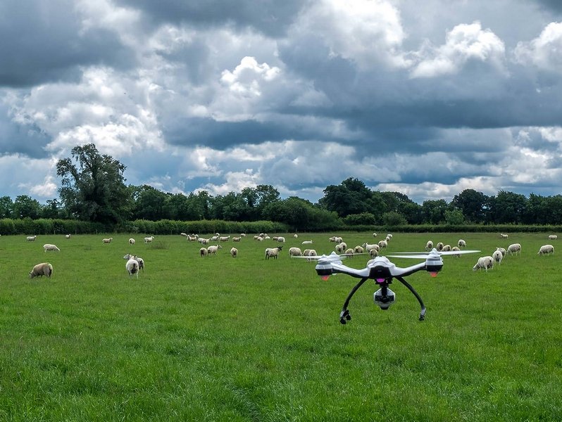
UAVs also began to be actively used in animal industry. Drones can not only monitor the location of the cattle herd, the movement of the herd, but can even control the direction of the animals.
The use of unmanned aerial vehicles in organic crops or non-GMO plants can be a marketing element that helps a manufacturer to sell its product at the best price.
Currently there are already companies that rent or sell drones. The cost of renting for a specialized operator can vary from $ 300 to $ 3000 and, in the case of a purchase, prices range from $ 6000 and $ 8,000, or from $ 30,000 to $ 45,000, depending on technology and reliability.


